


Editor's note in 2025: This map no longer loads via GitHub/Google Maps, but the link to see its methodology is still active, and we've listed the landmarks in the story. Read about Randy Olson's methodology here or in the story below.
When most people dream of using their vacation days, they fantasize about European castle tours or Caribbean cruises or African safaris — really anything outside of the United States (except maybe Hawaii). But for those of us who want to burn rubber on the good ol’ interstate system while channeling Jack Kerouac, there’s finally a US road-trip map that tells us exactly where to go.
The map, created by Randy Olson with help from Tracy Staedter, pinpoints a mix of 50 major national landmarks, national historic sites, national parks and national monuments. If you follow the route suggested, you’ll travel across all 48 contiguous states and never leave the country. Take a look for yourself below.
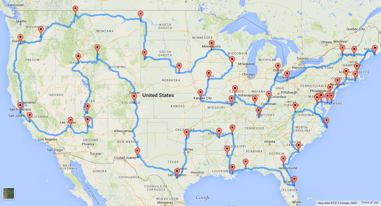
If you actually plan to execute the trip, you should budget 13,699 miles of driving — or about 224 hours. Attempting to do the trip in one go would take about 9.33 days, although Olson believes it would actually take 2–3 months to finish it in reality. And don’t even think about shortcutting or not following the map. Olson used a genetic algorithm that found the best routes with little backtracking. The result is a map using “true distance,” which is the “shortest route by road between every landmark.” You should probably take Olson’s word over anyone else’s, considering he’s a fourth-year graduate research assistant at Michigan State University.
Here's the full list of the landmarks in order:
- Grand Canyon, AZ
- Bryce Canyon National Park, UT
- Craters of the Moon National Monument, ID
- Yellowstone National Park, WY
- Pikes Peak, CO
- Carlsbad Caverns National Park, NM
- The Alamo, TX
- The Platt Historic District, OK
- Toltec Mounds, AR
- Elvis Presley's Graceland, TN
- Vicksburg National Military Park, MS
- French Quarter, New Orleans, LA
- USS Alabama, AL
- Cape Canaveral Air Force Station, FL
- Okefenokee Swamp Park, GA
- Fort Sumter National Monument, SC
- Lost World Caverns, WV
- Wright Brothers National Memorial Visitor Center, NC
- Mount Vernon, VA
- White House, Washington, DC
- Colonial Annapolis Historic District, MD
- New Castle Historic District, Delaware
- Cape May Historic District, NJ
- Liberty Bell, PA
- Statue of Liberty, NY
- The Mark Twain House & Museum, CT
- The Breakers, RI
- USS Constitution, MA
- Acadia National Park, ME
- Mount Washington Hotel, NH
- Shelburne Farms, VT
- Fox Theater, Detroit, MI
- Spring Grove Cemetery, OH
- Mammoth Cave National Park, KY
- West Baden Springs Hotel, IN
- Abraham Lincoln's Home, IL
- Gateway Arch, MO
- C. W. Parker Carousel Museum, KS
- Terrace Hill Governor's Mansion, IA
- Taliesin, WI
- Fort Snelling, MN
- Ashfall Fossil Bed, NE
- Mount Rushmore, SD
- Fort Union Trading Post, ND
- Glacier National Park, MT
- Hanford Site, WA
- Columbia River Highway, OR
- San Francisco Cable Cars, CA
- San Andreas Fault, CA
- Hoover Dam, NV
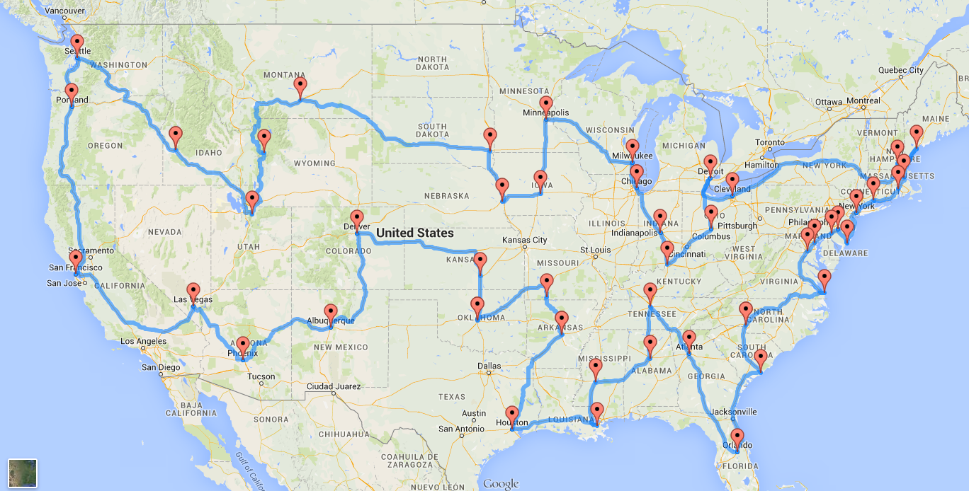
If you’re more into seeing cities than, say, Mount Rushmore, Olson also created a similar map that prioritizes TripAdvisor’s most recommended metros. This trip is only 12,290 miles but excludes cities from North Dakota, Vermont and West Virginia, since TripAdvisor says there’s nothing worth stopping for in those states. Here’s what the journey looks like (and the full list of metros is in his same post):
Sure, the map seems daunting, but road trips do mean blasting Spice Girls on the stereo, and who doesn’t love that?
h/t Washington Post; top photo courtesy of Angus MacRae/Flickr.
Written by By Ann-Marie Alcántara.
The Bold Italic is a not-for-profit media organization, and we publish first-person perspectives about San Francisco and the Bay Area. We operate under a fiscal sponsorship of a 501(c)(3).
You can become a paid subscriber. Or donate. Or learn more about us.